Watershed
Winooski Watershed
The Winooski Conservation District encompasses more than five different drainage basins including: the Winooski River Watershed, the LaPlatte River Watershed, and parts of the Lake Champlain, Lamoille and White River Watersheds. As the name of the District suggests, the Winooski River Watershed represents a great deal of the District and spans the three Counties in Vermont that we serve: Chittenden, Washington and the three towns in Orange County (Washington, Orange and Williamstown).
For a detailed account of the Natural Resources and priority concerns of the District, please view the WNRCD Natural Resource Assessment at the link below:
WNRCD 2015 Resource AssessmentGeography
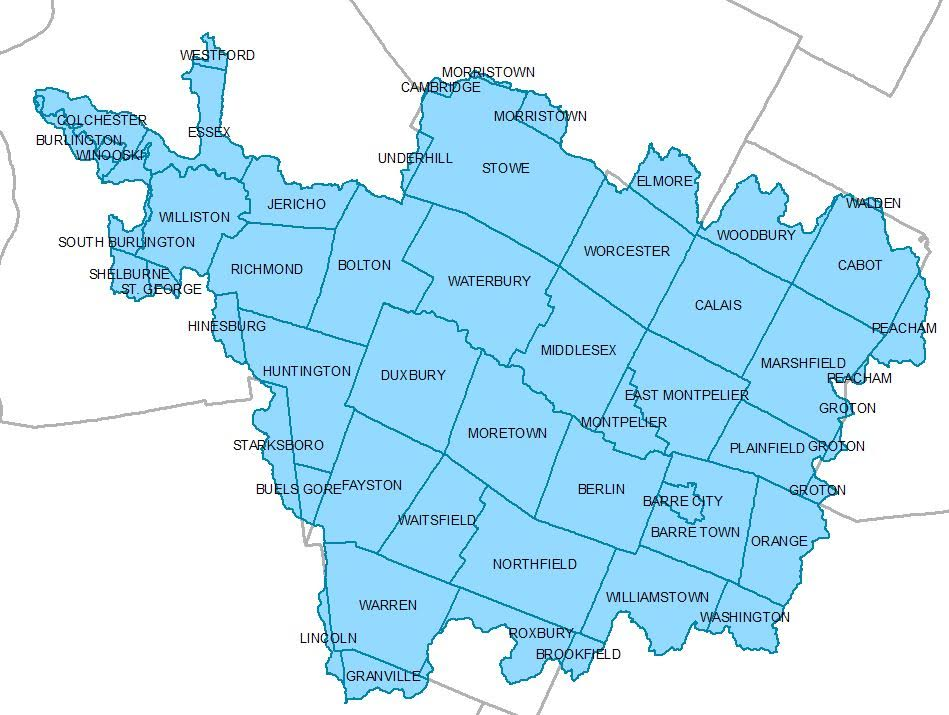
The Winooski River begins in the town of Cabot and flows 90 miles to Lake Champlain in Colchester. The watershed drains approximately 1,080 square miles. The Winooski River is the largest tributary to Lake Champlain and includes almost 10% of the land area of Vermont.
The Winooski River begins in the town of Cabot and flows through Marshfield, Plainfield, East Montpelier, Montpelier, Middlesex, Moretown, Waterbury, Duxbury, Bolton, Richmond, Jericho, Williston, Essex, Winooski, Burlington, and Colchester before entering Lake Champlain.
From its beginning in Cabot to the outlet in Colchester, the Winooski River drops 1700 feet in elevation. The total length of the Winooski River system (including its tributaries) is around 198 miles. The entire Winooski River Watershed is approximately 690,000 acres or close to 10% of the State’s total land area.
Land Use
Land use as of 2023 for the Winooski Basin, which takes up most of the District area, is 73% forested, 3% agricultural, 9% developed lands, and 9% surface waters, rivers, lakes, ponds and wetlands (2024 Basin 8 Tactical Basin Plan). Over the past 20 years, land use has shifted in this area with an increase in developed land and scrub, and a decrease in forested area and working agricultural lands (2024 Basin 8 Tactical Basin Plan). Approximately 75,600 acres of the watershed are owned by the State of Vermont and managed by the Agency of Natural Resources. The Federal government owns 12.900 acres within the watershed.
Tributaries of the Winooski River
- Alder Brook: Length: 10 miles, Watershed area: 6,762 acres
- Allen Brook: Length: 10 miles, Watershed area: 6,900 acres
- Dog River: Length: 18 miles, Watershed area: 60,030 acres
- Huntington River: Length: 20 miles, Watershed area: 43, 470 acres
- Jail Branch: Length: 16 miles, Watershed area: 31,050 acres
- Kingsbury Branch: Length: 12 miles, Watershed area: 34,500 acres
- Little River: Length: 15 miles, Watershed area: 71,070 acres
- Mad River: Length: 26 miles , Watershed area: 91,080 acres
- Mill Brook: Length: 9.5 miles, Watershed area: 10,350 acres
- Muddy Brook: Length: 5.5 miles, Watershed area: 16, 560 acres
- North Branch: Length: 18 miles, Watershed area: 48,300 acres
- Stevens Branch: Length: 13 miles, Watershed area: 82,800 acres